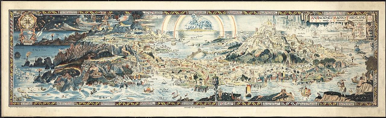
An Anciente Mappe of Fairyland by Bernard Sleigh, 1920
If you believe in fairies, this ancient map and guide will help you know them and find them
By Paul Sorene
Fairyland at PG:
https://www.gutenberg.org/ebooks/subject/37291
An Anciente Mappe of Fairyland by Bernard Sleigh, 1920
If you believe in fairies, this ancient map and guide will help you know them and find them
By Paul Sorene
Fairyland at PG:
https://www.gutenberg.org/ebooks/subject/37291
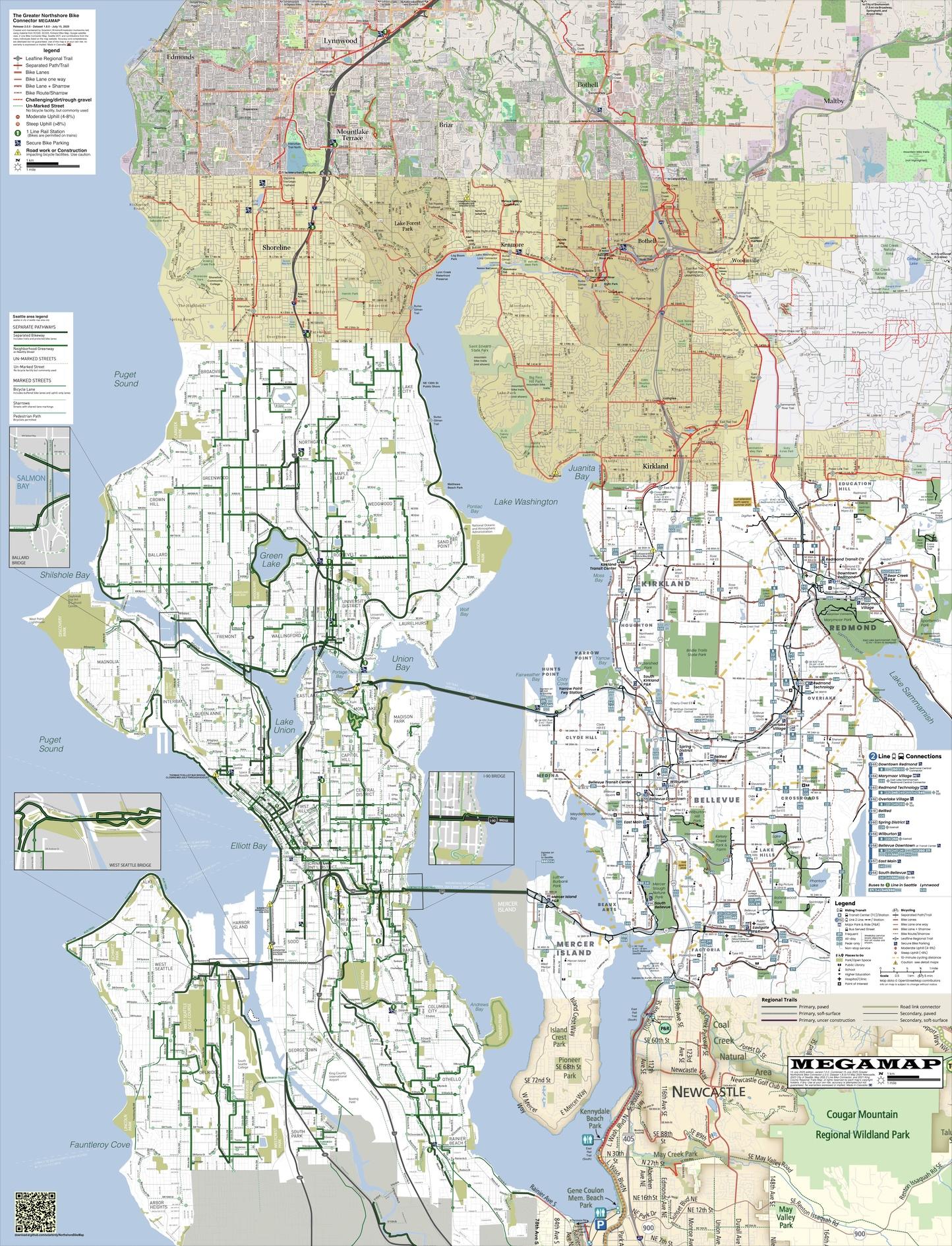
RELEASE: Greater Northshore and MEGAMAP Bike Maps version 2.0 - July 15, 2025
Additions and changes this release include a pretty big project of enlarging City of Seattle's street name labels, which were too damn small.
But there's more; check the blog post for changes and notes:
https://solarbird.net/blog/2025/07/14/maps-release-greater-northshore-bike-connector-megamap-2-0/
Maps download:
https://github.com/solarbirdy/NorthshoreBikeMap/
Previous permalinks continue to work.
If you like these maps, maybe hit my Patreon:
https://www.patreon.com/solarbird
Thanks!
#biking #BikeTooter #GreaterNorthshore #seattle #northshore #SnohomishCounty #Shoreline #Edmonds #MountlakeTerrace #LakeForestPark #Briar #Kenmore #Juanita #Kirkland #Bothell #Woodinville #Maltby #KingCounty #Redmond #BikeMap #maps #design
Last week we published a set of three in-depth #map reports covering territorial control across #Somalia's claimed territories from 2023 to present. The June 2024 report is free for all readers, and shows the height of "#IslamicState" (#ISIS/#ISIL) control in the country:
https://www.polgeonow.com/2025/06/somalia-territorial-control-map-2024-isis-shabaab.html
#HornOfAfrica #cartography #maps #geography #Somaliland #Puntland #SSC_Khaatumo #mapping @geography @cartography @geopolitics #AlShabaab #AlQaeda #security #OSINT
En.osm.town is an independent Mastodon server for people active in the OpenStreetMap community.
This server has been operating since 2018.
You can find out more at https://en.osm.town/about or contact the admin @compass
#FeaturedServer #OpenStreetMap #OSM #Geospatial #GIS #Maps #Mapping #Cartography #Mastodon #Fediverse #FreeFediverse
Mapstodon.space is a Mastodon server for cartography & geospatial professionals and enthusiasts. Ask questions, share your maps, chat around, enjoy the emojis!
You can find out more at https://mapstodon.space/about or contact the admin account @jeremy
#FeaturedServer #Maps #Mapping #Cartography #Geospatial #GIS #Geography #Mastodon #Fediverse #FreeFediverse
RELEASE: Greater Northshore and MEGAMAP Bike Maps version 2.0.1 - 4 August 2025
Updates this release are fairly minor EXCEPT for the decades-awaited connection from Elliot Bay Trail to Waterfront, and an important new set of bike lanes on Meridian in Shoreline.
As always, check the blog post for the deets:
https://solarbird.net/blog/2025/08/04/maps-release-greater-northshore-bike-connector-megamap-2-0-1/
Maps download:
https://github.com/solarbirdy/NorthshoreBikeMap/
Previous permalinks continue to work.
If you like these maps, maybe hit my Patreon:
https://www.patreon.com/solarbird
Enjoy!
#biking #BikeTooter #GreaterNorthshore #seattle #northshore #cascadia #SnohomishCounty #Shoreline #Edmonds #MountlakeTerrace #LakeForestPark #Briar #Kenmore #juanita #Kirkland #Bothell #Woodinville #Maltby #KingCounty #Redmond #BikeMap #maps #design
En.osm.town is an independent Mastodon server for OpenStreetMap people. Funding graciously provided by the OpenStreetMap Foundation.
This server has been online since 2018.
You can find out more at https://en.osm.town/about or contact the admin account @compass
#FeaturedServer #OpenStreetMap #OSM #Maps #Cartography #GIS #Geospatial #Mastodon #Fediverse #FreeFediverse
Because today is the June #solstice, here is my 2020 animated map of this solstice’s day-night cycle rendered using the #CahillConcialdi map projection, which is my most favorite.
Grab the file here: https://commons.wikimedia.org/wiki/File:Cahill%E2%80%93Concialdi_projection_(Natural_Earth_I)_day-night_animation_at_June_solstice.gif
💁🏻♀️ TIL: 🏖️📉 #California has lost roughly 60% of its coastal sand dunes since the 1850s, a loss of about 442 km².
Researchers used historical #maps, aerial #photos, and #lidar #data tracked by #machinelearning to measure the decline. Most losses came from development, #erosion, and invasive grasses, but some dunes expanded by 15 km² .
👉 https://www.zmescience.com/science/news-science/california-coastal-dunes-disappearing/
#coast #pacific #ocean #dunes #sanddunes #climate #climatechange #conservation #habitats #wildlife #environment #storms #restoration #science #geology
RELEASE: Greater Northshore and MEGAMAP Bike Maps version 2.1.2 - 5 June 2026
This is a pretty big north end update! Lots going on. Full deets at the blog:
https://solarbird.net/blog/2026/06/05/maps-release-greater-northshore-bike-connector-megamap-2-1-2/
Maps download:
https://github.com/solarbirdy/NorthshoreBikeMap/
Previous permalinks continue to work.
If you like these maps, maybe hit my Patreon:
https://www.patreon.com/solarbird
Enjoy!
#BikeMap #maps #GreaterNorthshore #seattle #shoreline #redmond #lynnwood #LakeForestPark #Kenmore #Briar #Bothell #Woodinville #Juanita #Kirkland #RatCity #Glendale #Lakeridge #BrynMawr #tukwila #WhiteCenter #TopHat #newcastle
RELEASE: Greater Northshore and MEGAMAP Bike Maps version 2.1.3 - 12 June 2026
This is part two of the big north end update that dropped last week, now that the lagging projects are OPEN!
Full deets at the blog:
https://solarbird.net/blog/2026/06/12/maps-release-greater-northshore-bike-connector-megamap-2-1-3/
Maps download:
https://github.com/solarbirdy/NorthshoreBikeMap/
Previous permalinks continue to work.
If you like these maps, maybe hit my Patreon ( https://www.patreon.com/solarbird ) or @annathepiper has a Kofi ( https://ko-fi.com/annathepiper ).
Enjoy!
#BikeMap #maps #GreaterNorthshore #seattle #shoreline #redmond #lynnwood #LakeForestPark #Kenmore #Briar #Bothell #Woodinville #Juanita #Kirkland #RatCity #Glendale #Lakeridge #BrynMawr #tukwila #WhiteCenter #TopHat #newcastle
RELEASE: Greater Northshore and MEGAMAP Bike Maps version 2.1.4 - 3 July 2026
Multiple small changes, most of which improve access to north end light rail stations.
Full deets at the blog:
https://solarbird.net/blog/2026/07/04/maps-release-greater-northshore-bike-connector-megamap-2-1-4/
Maps download:
https://github.com/solarbirdy/NorthshoreBikeMap/
Previous permalinks continue to work.
If you like these maps, maybe hit my Patreon ( https://www.patreon.com/solarbird ) or @annathepiper has a Kofi ( https://ko-fi.com/annathepiper ).
Enjoy!
#BikeMap #maps #GreaterNorthshore #seattle #shoreline #redmond #lynnwood #LakeForestPark #Kenmore #Briar #Bothell #Woodinville #Juanita #Kirkland #RatCity #Glendale #Lakeridge #BrynMawr #tukwila #WhiteCenter #TopHat #newcastle
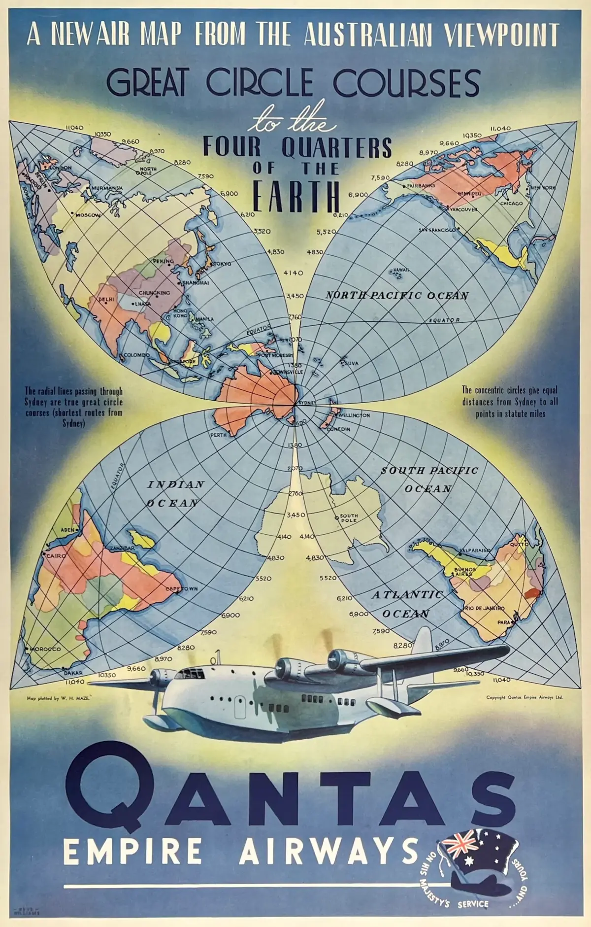
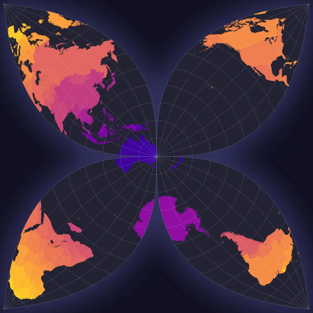
🧵 1/2: I recently saw this vintage #Qantas poster with a unique “flower” map projection centered on #Sydney (1st image). I love how it almost neatly divides the four largest continents (Eurasia, Africa, and North and South America) into the 4 “petals”.
I sorta became obsessed and wondered if I could recreate it using my mapmaking and coding skills.
Some days of tinkering, coding, and mathing later, I think I managed to do it! (2nd image) 🎉🗺️
RE: https://mastodon.art/@NickEast_IndieWriter/117172203765192969
With 40 votes the result of the poll is in:
97% think I should add images to The Last Philosopher ebook.
78% think I should add them as scene/chapter headers.
So, expect Part two to have images, mostly maps...
@fantasy @bookstodon @books @reading
@worldbuilding @humor
#Ebook #Ebooks #Indie #IndieAuthor #Map #Maps #Drawings
#SpeculativeFiction #FantasyBooks #Geek
#Fantasy #SciFi
#Novel #Books #Bookstodon
Recently I learned about TouchMapper: Create tactile maps easily for any address.
They use #OpenStreetMap to create printable 3D models of an area, for people with no/bad vision to literally get a feel for the place.
I love the initiative!
#maps #accessibility #inclusion #vision #3dprinting #AwesomeStuff
RELEASE: Greater Northshore and MEGAMAP Bike Maps version 2.1.6 - 10 October 2026
Honestly there are very few changes since the last release. But there are a couple. Full deets at the blog:
https://solarbird.net/blog/2026/10/10/maps-release-greater-northshore-bike-connector-megamap-2-1-6/
Maps download:
https://github.com/solarbirdy/NorthshoreBikeMap/
Previous permalinks continue to work.
If you like these maps, maybe hit my Patreon ( https://www.patreon.com/solarbird ) or @annathepiper has a Kofi ( https://ko-fi.com/annathepiper ).
Enjoy!
#BikeMap #maps #GreaterNorthshore #seattle #shoreline #redmond #lynnwood #LakeForestPark #Kenmore #Briar #Bothell #Woodinville #Juanita #Kirkland #RatCity #Glendale #Lakeridge #BrynMawr #tukwila #WhiteCenter #TopHat #newcastle
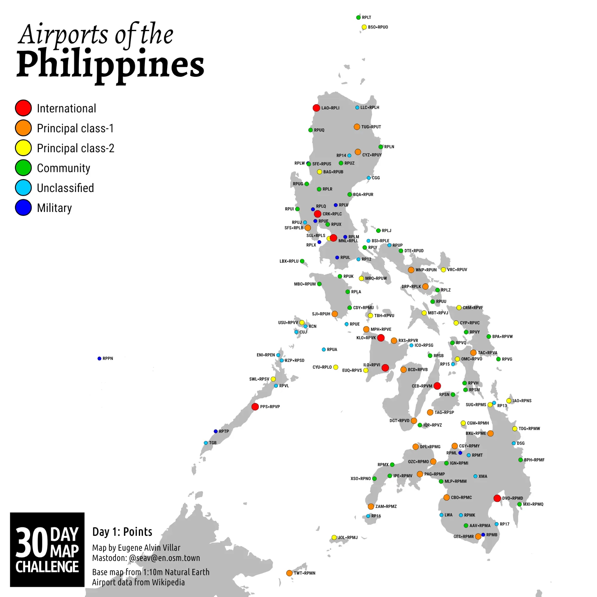
#30DayMapChallenge 🗺️ Day 1️⃣: Points ⏺️
Oh boy, another year of daily mapmaking!
For Day 1, I decided to create a map of the extant airports of the 🇵🇭 #Philippines that have either an IATA or ICAO code. I thought it would be a simple job, but parsing the data from #Wikipedia was pretty gnarly. Once I had clean data, the actual map creation using #D3js was pretty straightforward.
#avgeek #airports #aviation #maps #Mapstodon #cartography #gischat
Hi Mastodon! 👋 #introduction
I’m Edgar, and I built Terra Tempora: a free globe where you can scroll through history and watch borders, empires and events change over time.
It’s open source, with no ads and no tracking. Available in English, French and Spanish
🌍 https://terra-tempora.com/?ref=mastodon
Feedback and missing events are very welcome!
Note: this is coded using AI. Added this as some people complained that it was not mentioned.
Mapstodon.space is a Mastodon server for cartography & geospatial people including professionals and enthusiasts. Ask questions, share your maps, chat around, enjoy the emojis!
You can find out more at https://mapstodon.space/about or contact the server admin @jeremy
#FeaturedServer #Maps #Geospatial #Cartography #Mapping #Geography #GIS #Mastodon #Fediverse #FreeFediverse